Welcome to the Terra Lane Realignment Public Meeting
 What are the problems
The existing I-70 and Bryan Road interchange is very close to the interchange of West Terra and Bryan Road. This makes it difficult to move traffic through the area. This close spacing impedes traffic flow and often backs up traffic in all directions of the interchange. Drivers often have to wait through multiple signals especially during peak travel times.

What has been done?


Screening Criteria
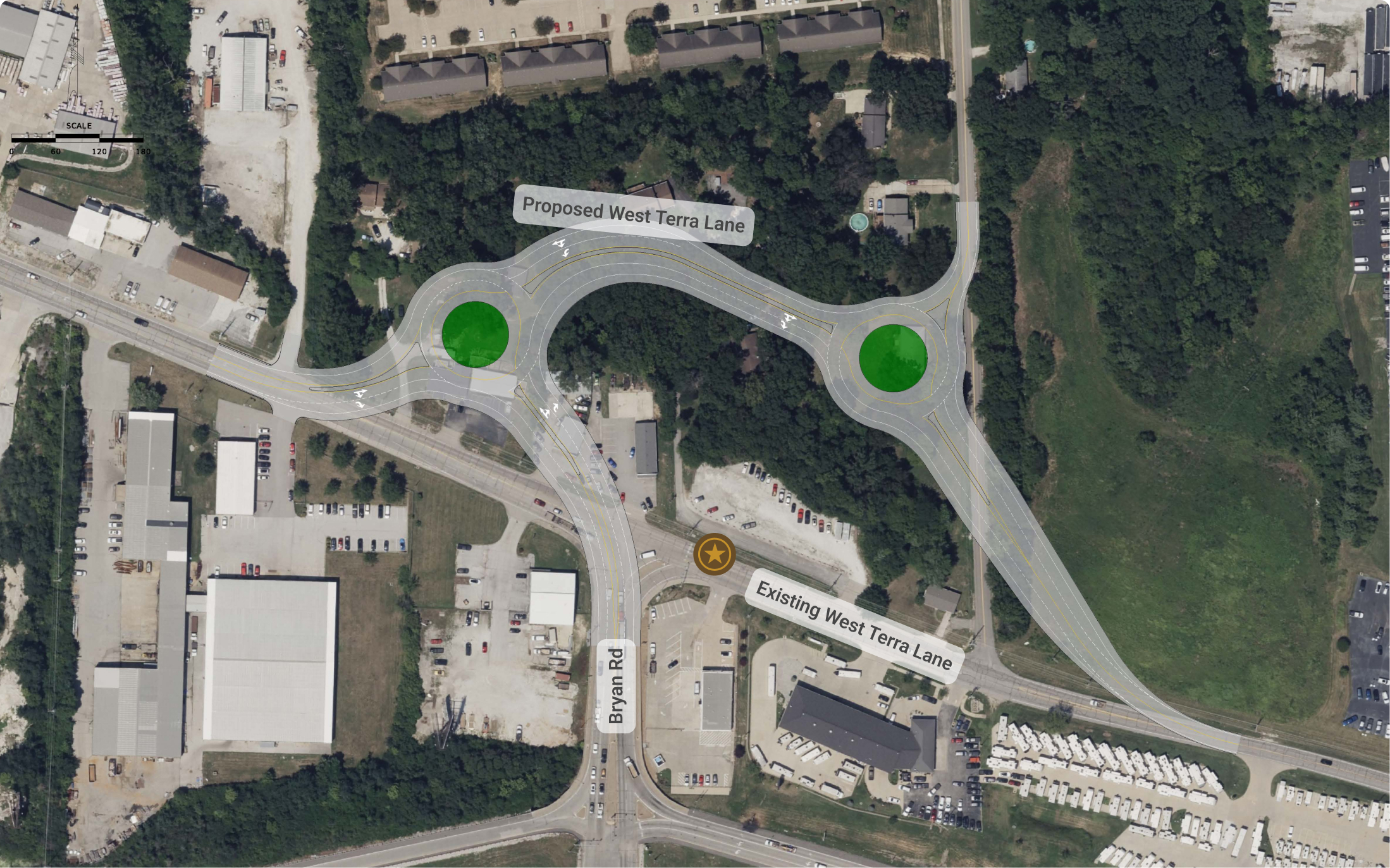
The design of the West Terra Lane Realignment will look to relocate the Bryan Road and West Terra Lane intersection to the north, giving more space from the I-70 and Bryan Road interchange.
The project team developed multiple concepts to improve safety, operations, and connectivity. Each conceptual alternative offers unique benefits to address these goals.
The screening method consists of eight qualitative criteria reflecting the goals and priorities of the study:
An empty circle indicates that the alternative does not meet or achieve a desired outcome.
A half-open circle indicates that the alternative partially meets or achieves a desired outcome.
A fully colored circle indicates that the alternative fully meets or achieves a desired outcome.
Alternative 1: Realigned Signal

It should be noted the intersection configurations presented within this screening memo should be considered conceptual in nature, and subject to change.
This intersection graphic is intended to show intersection geometry only. Connections to local business and other properties are not shown at this time.
Pros
- Improves signal spacing on Bryan Road
- Design is consistent with other intersections along Bryan Road
- Allows for some flexibility with the Bryan Road/Deer Creek extension
- Eases conflict with turning movements on Terra Lane and Bryan Road
- Can accommodate crosswalks and pedestrian signals
- No significant impact to existing heavy vehicle traffic
Cons
- Reduces site distance
- Will require significant right-of-way acquisition
- Turn lanes will still see heavy traffic
- Lengthy pedestrian crossing times needed
An empty circle indicates that the alternative does not meet or achieve a desired outcome.
A half-open circle indicates that the alternative partially meets or achieves a desired outcome.
A fully colored circle indicates that the alternative fully meets or achieves a desired outcome.
Alternative 2: Realigned Roundabout

It should be noted the intersection configurations presented within this screening memo should be considered conceptual in nature, and subject to change.
This intersection graphic is intended to show intersection geometry only. Connections to local business and other properties are not shown at this time.
Pros
- Expected to reduce crashes by more than 40%
- Operates well under all conditions
- Provides short pedestrian crossings
- Relatively simple roundabout
- Design reduces possible maintenance
- Accommodates heavy vehicle traffic
Cons
- Drivers may be unfamiliar with a multi-lane roundabout and multi-lane approaches
- Limited future adjustments to the roundabout
- Will require significant right of way acquisition
An empty circle indicates that the alternative does not meet or achieve a desired outcome.
A half-open circle indicates that the alternative partially meets or achieves a desired outcome.
A fully colored circle indicates that the alternative fully meets or achieves a desired outcome.
Alternative 3: Double Roundabout Dogbone

It should be noted the intersection configurations presented within this screening memo should be considered conceptual in nature, and subject to change.
This intersection graphic is intended to show intersection geometry only. Connections to local business and other properties are not shown at this time.
Pros
- Operates well under all conditions
- Provides short pedestrian crossings
- Design reduces possible maintenance
- Accommodate heavy vehicle traffic
- Allows for better alignment of Bryan Rd extension
Cons
- Drivers may have difficulty navigating
- Limited future adjustments to the roundabout
- Severe right of way impacts
- Substantially high costs
An empty circle indicates that the alternative does not meet or achieve a desired outcome.
A half-open circle indicates that the alternative partially meets or achieves a desired outcome.
A fully colored circle indicates that the alternative fully meets or achieves a desired outcome.
Alternatives Comparison
Alternative 1
Alternative 2
Alternative 3
No Build
Best Apparent Alternative: Alternative 2

It should be noted the intersection configurations presented within this screening memo should be considered conceptual in nature, and subject to change.
This intersection graphic is intended to show intersection geometry only. Connections to local business and other properties are not shown at this time.
Right of Way


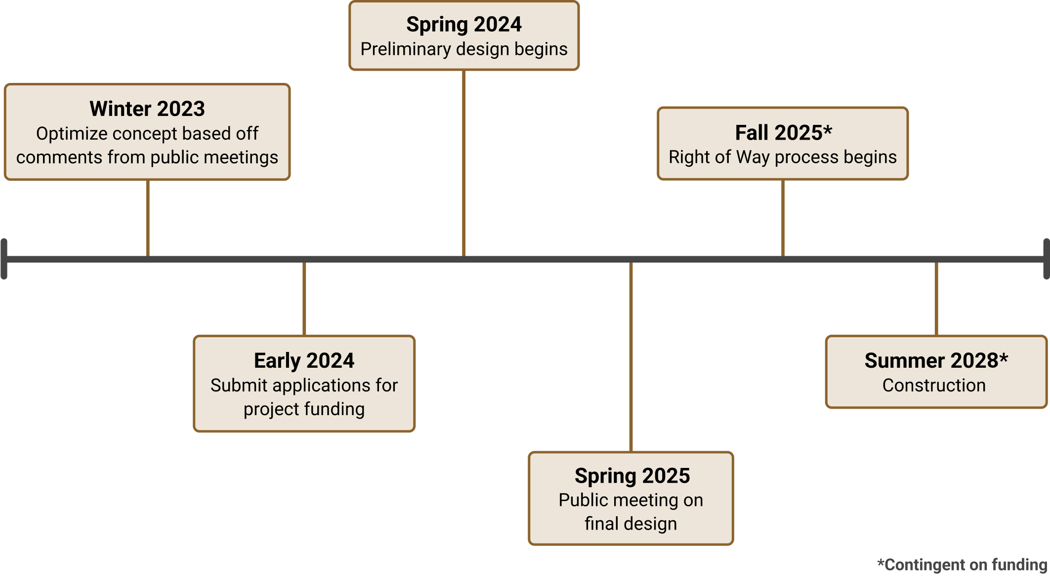
Next Steps

